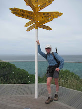
near Ngunguru to near Kauri Mountain - 35.7 km - 8 hours
Today was mostly a road walk day, starting from 2.3 km west of Ngunguru (near Tutukaka), with 10 km on the road to Whangarei to get to the head of the Ngunguru estuary, and then head back along a minor road to the start of the Mackerel Forest Walk.
That started off pleasantly through a pine plantation that looks set to get the chop soon, down to the Waitangi River - the walk description said knee / thigh depth, but actually was not much more than ankle deep - very dry right now. Then followed the stream on the ed
 ge of a logged area, with the track being that bit harder to follow, and with gorse to make it that more ... interesting. Some swampy areas too, before climbing up through a mature forest and out onto my next road.
This headed off to the Horahora Estuary (mangroves galore) and then around to Pautaua where again the only way across the estuary was via a footbridge - with people jumping off into the turquoise river below (picture). Then on to the Tahururu Estuary getting close to high tide, so not being a strong swimmer, the alternative to the Te Araroa low tide route took me to the corner of Tahururu and Pautau roads.

No comments:
Post a Comment