While I was waiting to get back up to Northland to complete the leg to Auckland, I started on the closer sections of the Te Araroa route south from Auckland. This is in a new blog - Tony on Te Araroa 2 - so click on that link to track my progress further south.
So far from Cape Reinga to home in Auckland I have covered 639 km in 21 days' walking, with an average day being 30.4 km, 7.3 hours and 4.2 kph. A lot of variation within that - the slowest days including serious tramping tracks.
Sunday, March 14, 2010
Redvale to Epsom
38.8 km - 7.6 hours
From Redvale (north east of Albany) it was road walking for a bit to get to Long Bay, continuing my bypass of the muddy Okura River. From there down the coast through all the North Shore Bays, with super beaches, and super views from up on the cliffs in between. Took advantage of the outgoing tide to skip some of the cliffs and roads, including continuing at sea level from the south end of Takapuna beach through to Narrow Neck beach (You can't do that at a high tide).
On Cheltenham Beach I paused briefly to watch two of the Loius Vuiton y achts rounding a mark, and then headed off to Devonport to catch the ferry to downtown Auckland. Then a very familiar walk on the Coast to Coast walkway (where I broke the back of my Oxfam Trailwalker training a few years ago) through the university, Auckland Domain, and up to the summit of Mt Eden (view looking back to Rangitoto - pic) before heading to my home in Epsom
From Redvale (north east of Albany) it was road walking for a bit to get to Long Bay, continuing my bypass of the muddy Okura River. From there down the coast through all the North Shore Bays, with super beaches, and super views from up on the cliffs in between. Took advantage of the outgoing tide to skip some of the cliffs and roads, including continuing at sea level from the south end of Takapuna beach through to Narrow Neck beach (You can't do that at a high tide).
On Cheltenham Beach I paused briefly to watch two of the Loius Vuiton y
 achts rounding a mark, and then headed off to Devonport to catch the ferry to downtown Auckland. Then a very familiar walk on the Coast to Coast walkway (where I broke the back of my Oxfam Trailwalker training a few years ago) through the university, Auckland Domain, and up to the summit of Mt Eden (view looking back to Rangitoto - pic) before heading to my home in Epsom
Saturday, March 13, 2010
Wenderholm to Redvale (just north of Auckland)
28.5 km - 6.8 hours
A later start than usual to ensure the tide was OK - so left Wenderholm at the canoe landing place at 9.40 heading up a much improved track around the Wenderholm peninsula, with great views down to the river mouth, out to sea, and in the distance, what was probably the Dome summit.
The track then continued on down and around, taking me to the bridge at Waiwera , and from there it was out to the beach for the low tide section. This was a mixture of beach (cliff picture) and rock walking and rock scrambling all the way around to Hatfields Beach. Then various paths up the next hill, with a great view down Orewa Beach. Along that beach (mostly not on sand), to the western end of the Whangaparoa Peninsula and after not too long down to the northern edge of the Weiti River.
An obliging boatie rowed me across to a non muddy landing spot, so then I was off again on the Okura walk - the first part taking advantage of the lowish tide to skip a few hills. The official Te Araroa route involves a muddy Okura River crossing, so I skipped that and continued on the bush track to its end, walking up to East Coast Bays road for my pickup for the day.
28.5 km - 6.8 hours
A later start than usual to ensure the tide was OK - so left Wenderholm at the canoe landing place at 9.40 heading up a much improved track around the Wenderholm peninsula, with great views down to the river mouth, out to sea, and in the distance, what was probably the Dome summit.
The track then continued on down and around, taking me to the bridge at Waiwera
 , and from there it was out to the beach for the low tide section. This was a mixture of beach (cliff picture) and rock walking and rock scrambling all the way around to Hatfields Beach. Then various paths up the next hill, with a great view down Orewa Beach. Along that beach (mostly not on sand), to the western end of the Whangaparoa Peninsula and after not too long down to the northern edge of the Weiti River.
An obliging boatie rowed me across to a non muddy landing spot, so then I was off again on the Okura walk - the first part taking advantage of the lowish tide to skip a few hills. The official Te Araroa route involves a muddy Okura River crossing, so I skipped that and continued on the bush track to its end, walking up to East Coast Bays road for my pickup for the day.
Friday, March 12, 2010
Dome Tearooms to Puhoi
Friday 12th March
Dome Tearooms - pine forest - farmland - pine forest - Moir Hill - Dunns Ridge - Puhoi village. 26.5 km - 5.75 hours
Leaving into a shower or two (first rain since before Kerikeri) up a minor road soon leaving the sound of a busy SH1 behind me. Then along forest roads, with a short connecting foot track, down into Streamlands, then more minor roads and farm paddocks to the start of the walk into the pine plantation leading to Moir Hill.
Forest roads then wound there way steadily uphill until the cellphone tower on Moir Hill was reached. Fried there for a while before heading down a minor forest track, cr ossing a minor road, through a new subdivision and onto Dunns Ridge Track. This took me down through open bush, before reaching an open ridge down through a farm to the quiet roads that then led me to the village of Puhoi.
The next section of Te Araroa is via canoe down the river to Wenderholm - I had done that with the family in January (picture) - just as well, since on checking, Puhoi Canoes had other plans for tomorrow, so tomorrow I will be starting from Wenderholm
Dome Tearooms - pine forest - farmland - pine forest - Moir Hill - Dunns Ridge - Puhoi village. 26.5 km - 5.75 hours
Leaving into a shower or two (first rain since before Kerikeri) up a minor road soon leaving the sound of a busy SH1 behind me. Then along forest roads, with a short connecting foot track, down into Streamlands, then more minor roads and farm paddocks to the start of the walk into the pine plantation leading to Moir Hill.
Forest roads then wound there way steadily uphill until the cellphone tower on Moir Hill was reached. Fried there for a while before heading down a minor forest track, cr
 ossing a minor road, through a new subdivision and onto Dunns Ridge Track. This took me down through open bush, before reaching an open ridge down through a farm to the quiet roads that then led me to the village of Puhoi.
The next section of Te Araroa is via canoe down the river to Wenderholm - I had done that with the family in January (picture) - just as well, since on checking, Puhoi Canoes had other plans for tomorrow, so tomorrow I will be starting from Wenderholm
Thursday, March 11, 2010
Matakana to Dome Tearooms SH1
Thursday 11th March
From Matakana township up the valley and then up the hill soon joining the track through the Waiwhiu valley and up again to the Dome summit, then down to the Dome tearooms on SH1 just north of Warkworth - 21.6 km - 5.5 hours
One day the Matakana dogleg of busy roads will be replaced by the Western Tamahunga track. But not yet, so up the valley road from the township to the hills, and then winding up and up to a minor road turnoff. Along that road with views out to the north as far as the Mangawhai Cliffs and Whangarei Heads which I now know a lot better than a week ago.
Then to the start of the tramping track that goes first along a forest road, t hen wends its way down a ridge line into the Waiwhiu Valley. The track winds its way on the hill side of the stream for a while, then does a quick dive across the stream at a place of large boulders (picture), and then out into the open on a forestry road. A side road then goes up the other side of the valley, before the tramping track resumes near the top. That then follows the ridge line around to the Dome summit (with views out to Omaha / Kawau), and then heads down to the end of the track on the side of SH1
From Matakana township up the valley and then up the hill soon joining the track through the Waiwhiu valley and up again to the Dome summit, then down to the Dome tearooms on SH1 just north of Warkworth - 21.6 km - 5.5 hours
One day the Matakana dogleg of busy roads will be replaced by the Western Tamahunga track. But not yet, so up the valley road from the township to the hills, and then winding up and up to a minor road turnoff. Along that road with views out to the north as far as the Mangawhai Cliffs and Whangarei Heads which I now know a lot better than a week ago.
Then to the start of the tramping track that goes first along a forest road, t
 hen wends its way down a ridge line into the Waiwhiu Valley. The track winds its way on the hill side of the stream for a while, then does a quick dive across the stream at a place of large boulders (picture), and then out into the open on a forestry road. A side road then goes up the other side of the valley, before the tramping track resumes near the top. That then follows the ridge line around to the Dome summit (with views out to Omaha / Kawau), and then heads down to the end of the track on the side of SH1
Wednesday, March 10, 2010
Mangawhai to Matakana

Wednesday 10th March
Te Arai beach - Pakiri - up and over Mt Tamahunga - roads to Matakana - 31.4 km - 7.6 hours
Onto the top end of Te Arai beach, then down the beach, with Te Arai Point to climb over part way along. Then on for another couple of hours to Pakiri - with racing horses training their silky riders on the beach for something a little different. An easy wade through the Pakiri river near the mouth, and then via a dusty road to the start of the real hill section for the day.
This climbed steeply up through dry paddocks to a ridge top with views to the north (picture) and then up and down, and then up again to the top of Mt Tamahunga, now with views out east to Omaha and Kawau Island. Down the other side, onto a road, that soon became the busy road from Leigh to Matakana.
Now able to stay at home in Auckland, so a chance to catch up with my blog .. and the rest .. while I finish off the last of the north Auckland section in the next few days
Waipu to Mangawhai
Tuesday 9th March
From near Waipu Cove to south of Mangawhai township, near the top end of Te Arai Beach - 33 km - 7.5 hours
From the main road near Waipu Cove, the day started with a walk up a road into the Brynderwyn Hills. The road became a shingle vehicle track winding up through the pines - then near the top there was a car coming down - from one of several houses in the trees right at the top.
Then a fairly straightforward following of the orange marker posts and my GPS and map along the tops - as promised there were a number of side tracks to watch out for.
for.
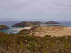
Then down through some good patches of regenerating kauri to cross the main Waipu to Mangawhai road, next up (and down and up) again through some very parched farmland to reach the Mangawhai Cliffs walkway. I followed that high up the cliffs for a way with some spectacular views (picture), down to the beach, and then to the town of Mangawhai Heads.
A super estuary to walk around, and then up to the main road for a walk around to Mangawhai (Point) township, and then on via a dusty back road to the start of the forest road that will tomorrow take me onto Te Arai Beach
From near Waipu Cove to south of Mangawhai township, near the top end of Te Arai Beach - 33 km - 7.5 hours
From the main road near Waipu Cove, the day started with a walk up a road into the Brynderwyn Hills. The road became a shingle vehicle track winding up through the pines - then near the top there was a car coming down - from one of several houses in the trees right at the top.
Then a fairly straightforward following of the orange marker posts and my GPS and map along the tops - as promised there were a number of side tracks to watch out
 for.
for.Then down through some good patches of regenerating kauri to cross the main Waipu to Mangawhai road, next up (and down and up) again through some very parched farmland to reach the Mangawhai Cliffs walkway. I followed that high up the cliffs for a way with some spectacular views (picture), down to the beach, and then to the town of Mangawhai Heads.
A super estuary to walk around, and then up to the main road for a walk around to Mangawhai (Point) township, and then on via a dusty back road to the start of the forest road that will tomorrow take me onto Te Arai Beach
Subscribe to:
Posts (Atom)